Valley Journal
Valley Journal

This Week’s e-Edition

Current Events

Latest Headlines

What's New?

Send us your news items.

NOTE: All submissions are subject to our Submission Guidelines.

Announcement Forms

Use these forms to send us announcements.

Birth Announcement
Obituary

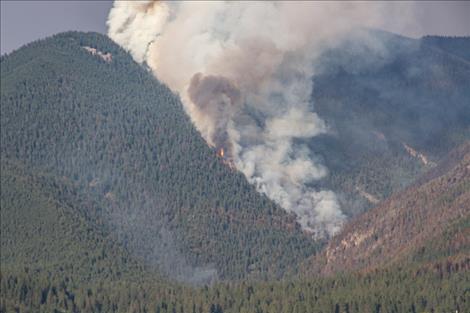
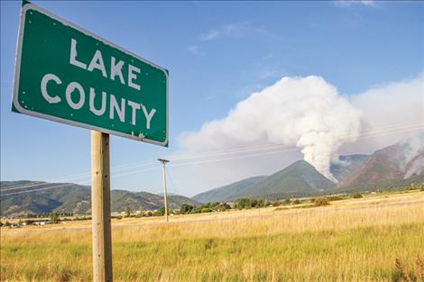
Numerous wildfires burn throughout county, reservation

Hey savvy news reader! Thanks for choosing local. You are now reading
1 of 3 free articles.


Subscribe now to stay in the know!

Already a subscriber? Login now

News from CSKT Division of Fire

FLATHEAD RESERVATION — Though cooler weekend weather and rains have helped suppression efforts, several large wildfires continue to burn on the Flathead Reservation. 

The Big Knife Wildfire, discovered on July 24, was started by lightning and has burned 4,864 acres as of Aug. 6. Burning approximately 5 miles east of Arlee, the fire is 0% contained and has caused the loss of four structures. 

Saturday’s moisture over the Big Knife Fire area helped moderate fire behavior and growth, and the fire primarily burned in the heavy fuels-backing, flanking, and creeping. The fire is burning in extremely steep terrain, fueled by heavy timber and significant dead and down fuels. Heavy equipment operators completed a mastication line along the fire’s southwestern edge to reduce fuels, and firefighters continued holding and improving a strategic firing operation they completed late Friday to keep the fire north of Agency Creek. Aircraft are aiding crews as conditions allow, although limited visibility has hindered some air operations.

The Montana Red Cross has opened an evacuation shelter for evacuees of the Big Knife Fire. The Red Cross shelter is located at the Arlee Community Center, 34086 Pow Wow Road. The phone number for the Montana Red Cross is 800-272-6668.

The Communication Butte Wildfire, discovered on July 30, burned 1,423 acres and is 100% contained.

The Niarada Wildfire, located 12 miles west of Elmo, discovered July 30, has burned 17,514 acres as of Aug. 6 and is 0% contained. 

The Niarada Fire also received some very light precipitation Saturday, sufficient to help moisten fine (grassy) fuels but insufficient to be considered a “wetting rain.”  Heavy fuels near the fire’s southeastern perimeter continued to torch Saturday. Fixed-wing scooper planes supported ground crews to help cool heavy fuels and catch the fire as it came into the grass west of White Earth Creek. Crews continued to assess and prepare structure protection measures northwest of Elmo if erratic winds push the fire in that direction again. Firefighters also continued holding and mopping up line north of Highway 28, along Cromwell Creek Road. This weekend’s moisture will allow crews to capitalize on reduced fire behavior. Firefighters will be working on a direct line along the fire’s southeastern fire edge where it is safe. 

The Lake County Sheriff’s Office implemented evacuations of approximately 150 residences and the Red Cross has opened a shelter in Polson. Located at the Polson High School, 1712 2nd St. W, the shelter provides a safe place to stay, meals, and access to community resources.

The Mill Pocket Fire located three miles west of Hwy. 28 has burned 2,135 acres and is 0% contained.

Firefighters working the Mill Pocket Fire continue to hold and improve the fireline around the fire’s northwestern perimeter, which is hung up in scree fields.

The Middle Ridge Wildfire, located 15 miles west of Ronan and discovered on July 30, has burned 13,000 acres and is 30% contained.

Weather and Fire Behavior

Much-needed precipitation began occurring over all fire areas Saturday; however, amounts vary significantly between Arlee and Elmo. Humidity and fuel moistures around the Niarada and Mill Pocket fires continue to be drier than those around the Big Knife Fire. Meteorologists forecast increased potential for thunderstorms and precipitation Sunday, with a slight drying trend into next week. Although incoming moisture may help temporarily moderate potential fire behavior (lessening the chance of long runs and torching in the short term), thunderstorms also bring concerns about erratic, outflow winds. Weather conditions and trends show continued potential for active fire behavior in the coming week.

Closures and Special Messages

The Lake County Sheriff has placed several areas near the base of the mountains west of the Big Knife Fire in PRE-EVACUATION status. See the map for those locations in yellow (Jocko, Canal, Francis). In the Tribal Primitive Area, Belmore Slough and Burnt Cabin Roads are closed.

Near the Niarada Fire, the Lake County Sheriff placed several residences in the following areas in-EVACUATION status Friday afternoon: Alexander Road, Early Dawn Road, Spring Lane Road, Walking Horse Lane, Windward Heights Road, Wildhorse View, Buffalo Bridge Road, Saddle Drive, Island Butte Lane, Bridle Path, Ten Deuce Way, Cliffview Drive, and Ricketts Road. The remainder of the town of Elmo is in READY status. The Flathead County Sheriff’s Office has issued a PRE-EVACUATION WARNING for Hubbart Dam Rd/NF-544 from the intersection of Crossover Rd South to Hwy 28. A MANDATORY EVACUATION remains in place from the top of the Pass on Brown’s Meadow Road South to Hwy 28, Nirada. This mandatory evacuation also includes Kofford Ridge Rd.

Fire managers are working with the Lake and Flathead County sheriff’s offices to constantly address the current evacuation orders.  The decision to lift or expand any evacuation areas or status is made based upon the current and predicted fire conditions, done in concert with all decision-making parties, and will be announced through official channels.

Use extreme caution when driving on Highway 28. Authorities reduced speed limits to 45 mph due to poor visibility, and firefighters and equipment are still working in the area. 

Wildfire updates and information can be found at: mtfireinfo.org or at the CSKT Division of Fire’s Facebook page. 

Sponsored by: