


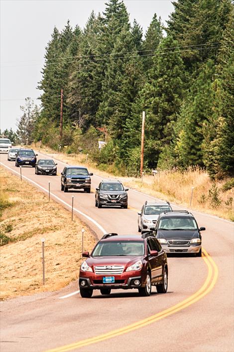
Take extra care driving twisty roads around lakes, mountains
We mapped five years of Montana highway crashes. Here’s what jumped out at us.
Hey savvy news reader! Thanks for choosing local.
You are now reading
1 of 3 free articles.
In wide-open Montana, long drives on the highway are a way of life and, often, a source of danger. The state is ranked fifth for the number of fatal accidents per resident, with 90% of those fatalities happening on roads outside of city limits.
Like many Montanans, MTFP’s staff puts in plenty of miles as we work to cover the state. On those drives, we sometimes wonder which stretches of the state’s vast highway network are the most prone to crashes.
We analyzed public crash data from the Montana Department of Transportation to answer that question for the state and federal roads that connect Montana’s cities and towns. Statewide, the average crash rate on routes where MDT publishes traffic data is about 134 accidents per 100 million vehicle miles traveled. For drivers who put in 15,000 miles a year, that’s about one crash every 50 years.
Among the takeaways is that interstates are generally less crash-prone than non-interstate highways, while the most crash-prone routes often snake over highway passes, in some cases on routes initially designed for wagons rather than modern cars. The data, unfortunately, doesn’t give us a good way to explore common crash factors like winter storms, animal collisions or impaired driving.
MDT divides the highway grid into short segments that typically range in length from less than a mile to a few miles long. We calculated and mapped crash rates for each of those segments, using data for 2019 to 2023 that includes all accidents “reported to and investigated by” law enforcement. The resulting crash index figures account for both traffic numbers and road section length, making the results directly comparable between different highways.
Those crash indexes vary wildly across the state highway grid. Looking at segments that are at least half a mile long and average at least 1,000 vehicles a day, some have crash rates that are as high as 5.5 times the state average. Other stretches are less crash-prone, with hardly any crashes or, in some cases, none at all.
Here’s what we found:
Interstates are typically low-crash routes — but not I-90 over Bozeman Pass
Interstates are typically much safer than normal highways for a variety of reasons, including their controlled access via on- and off-ramps, one-way traffic, and lack of intersections. The crash index for Montana interstates in the five-year period we looked at was 90, versus the 134 figure for all highways.
Bozeman Pass, on Interstate 90 between Bozeman and Livingston, is an exception. In combination with it being the busiest section of rural interstate in Montana, its tight corners help produce an accident rate nearly four times the average for Montana interstates. That makes it by far the most crash-prone section of interstate we identified.
Beware twisty mountain passes and highway junctions
As is the case with Bozeman Pass, many of the state’s most accident-prone stretches hug lake shorelines or twist through difficult terrain.
Another example, U.S Highway 93 just north of the Montana-Idaho border contains a winding three-mile section of road through Lost Trail Pass that has suffered accidents at nearly four times the statewide average. Another serpentine stretch eight miles further north, starting at Sula, also sees high crash rates at over three times the typical rate.
Further north, the intersection of U.S. 12 and U.S. 93 at Lolo also demonstrates the accident risk that can be posed by intersections. While the accident rate on U.S. 12 is elevated above the state average all the way to Lolo from the Idaho border, it spikes at more than five times the state average at the junction of the two highways.
Few crashes on the sparse-traffic plains
In eastern Montana where the Rockies give way to the Great Plains, we noticed two things: First, the long, straight roads of this part of the state typically have low crash rates compared to their western Montana counterparts.
Second, low traffic volumes — as light as a few dozen cars a day on average on some segments, compared to thousands on most western Montana routes — mean that even a small number of crashes can push the index on eastern Montana routes toward the top of our scale.
For example, a stretch of Montana Highway 24 that intersects with U.S. Highway 87 between Jordan and Circle had only two recorded crashes in the five years we looked at — but ends up with a crash rate double the state average because it averages only 220 cars a day.
A stretch of Montana Secondary Highway 467, or Union Road, just south of Circle is in the same boat. There, with just 63 vehicles a day on average, two crashes are enough to push that segment to roughly four times the average crash rate.
Other highlights
A couple of other areas around the state also stood out as interesting to us. Among them is the region around Helena, the state capital, which includes several high-accident segments.
Among the high-crash-rate segments in the Helena area is Montana Secondary Highway 518, which connects Montana City to East Helena, providing a popular way to bypass Helena when traveling between East Helena and Interstate 15. A two-mile section of road on the Montana City side of the stretch boasts a crash rate over three times the statewide average.
Montana Secondary Highway 279, better known as Lincoln Road, has multiple sections with elevated accident rates, including one through Flesher Pass that shows how the hairpin turns often forced by the mountains lead to higher accident rates — nearly 4.5 times the state average in this case.
MDT, which notes Lincoln Road was a homestead-era wagon trail later paved for cars without being realigned for modern travel, has scheduled a $15.5 million project on the route for 2028. The investment will focus on a six-mile stretch on the outskirts of Helena, where the crash rate is around three times the state average, instead of the high-crash Flesher Pass section. MDT says the project will reduce hazards and “accommodate future Helena Valley growth.”
One last stretch that caught our eye was a stretch of U.S. Highway 212 southwest of Billings, which bucks the typical trend of lower eastern Montana crash rates.
From 2019 to 2023 the section of U.S. 212 between Boyd and Fox saw an elevated accident rate nearly double the statewide average. The time period overlaps with multiple rounds of construction by the state highway department meant to improve its safety.
Nearby Montana Secondary Highway 421, or Joliet Road, is a popular way to avoid Interstate 90 and shorten the distance from Columbus to the communities along U.S. 212. It sees less traffic but an even higher accident rate, more than double the statewide average.
About the numbers in this piece
For this analysis, MTFP relied on two main types of public data from the Montana Department of Transportation: 2019-2023 crash records and average traffic volumes for those same years. Using a Python programming script, we connected each recorded crash to the matching stretch of road. We used this data to calculate a crash rate index expressed as accidents per 100 million vehicle miles traveled (VMT), an industry standard. The 100 million VMT metric measures crashes against every mile driven on that road, allowing for fair comparison of accident rate regardless of traffic or road length.
The data we were able to easily obtain from MDT’s website and from its staff via email doesn’t include information on crash severity, such as which accidents resulted in serious injury or fatalities. It also doesn’t track causes, such as which crashes were the result of vehicle collisions with animals or which involved intoxicated drivers. We filed a records request for more detailed data in late September; it was still pending as of late October.
Our analysis is a simplified version of what MDT itself produces as part of more comprehensive safety evaluations. The state’s engineers use additional factors such as crash severity, the role of intersections and many other roadway characteristics that are outlined in detail in the U.S. Department of Transportation’s 160-page Highway Safety Improvement Program Manual.
All underlying MDT data, the processed datasets, analysis code, and instructions for replicating the results are available in a GitHub repository.