


Big Knife Fire update
Hey savvy news reader! Thanks for choosing local.
You are now reading
1 of 3 free articles.
News and graphic from Northern Rockies Incident Management Team
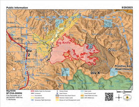
ARLEE — As of Aug. 20: On the north edge of the fire along S. Canal Road, the fire is backing down toward the canal. The areas with the most intense heat on the fire are located on the northeast side of Gold Creek drainage with some single tree torching events yesterday. Crews finished removing snags and continue to monitor and patrol the area both day and with night shift. On the south end of the fire in the Agency Creek drainage, crews are continuing to patrol and monitor fire activity. On the east side of the fire near Jocko Lookout, crews are conducting power line assessments and will continue monitoring the pumps and sprinkler systems in the primitive area.
The Big Knife Fire is currently 1.25 miles north of the Rattlesnake Wilderness Boundary (Lolo National Forest) with no significant growth towards the Lolo National Forest in the last week. Smoke from the fire may impact the Snowbowl area, however the Lolo National Forest does not have any forest closures in place on the Missoula Ranger District.
Closures and Special Messages: Several areas near the base of the mountains west of the Big Knife Fire remain in “Pre-Evacuation Warning” by order of the Lake County Sheriff. See the map for those locations in yellow (Jocko, Canal, Francis). The Tribal Primitive Area, Belmore Slough and Burnt Cabin Roads are closed.
A “Pre-Evacuation Warning” means you may be in your home. Individuals in this status should not bring back evacuated livestock until the area is downgraded to “Ready” status.
A temporary flight restriction (TFR) is in effect around the fire area. Do not fly unmanned aircraft (drones) near the fire areas.
Weather: Cloudy weather is expected today with possible thunderstorms. Remnants of Hurricane Hilary are expected to arrive and bring moisture over the Northern Rockies, with the heaviest rains on Sunday through Wednesday.
Fire Restrictions: Stage 2 fire restrictions are in place across the Flathead Indian Reservation. No campfires are allowed, no smoking outside of vehicles, no operating combustible engines from 1 p.m. to 1 a.m., no operating vehicles off designated roads and trails. Stage 1 fire restrictions are in place in Granite County. The following are prohibited until rescinded: Building, maintaining, attending, or using a fire or campfire except within a developed recreation site or improved site. Smoking, except within an enclosed vehicle or building, a developed recreation site or while stopped in an area at least three feet in diameter that is barren or cleared of all flammable materials. Visit: https://www.mtfireinfo.org/ for more fire restriction information across Montana.