


Polson quake rocks the web
Megan Strickland
Earthquakes rocked the Dayton and Wild Horse Island areas throughout December, but were nowhere near as strong as the magnitude 22 quake, the U.S. Geological Survey erroneously put out a bulletin about on Dec. 24.
Hey savvy news reader! Thanks for choosing local.
You are now reading
1 of 3 free articles.
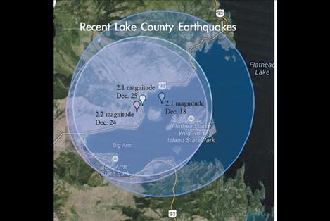
POLSON — A small 2.2 earthquake 12 miles northwest of Polson caused a bit of alarm on Christmas Eve, but the initial shaking wasn’t to blame.
The United States Geological Survey sent out a text message to people registered to receive earthquake updates that stated a 22 magnitude earthquake rattled Western Montana, with its epicenter near Polson. Later the quake registered as a 9.9 on the organization’s homepage.
“Thankfully it’s erroneous,” University of Oklahoma geoscience Ph.D. student Jefferson Chang tweeted soon after the message went out. “‘Cause, you know, we’d probably have another moon.”
Michael Stickney is director of the Earthquake Studies Office at the Montana Bureau of Mines and Geology, which is a part of Montana Tech of the University of Montana in Butte. His office filters the raw data from 37 seismographs across the state and relays it through an electronic network that posts to the USGS website, which sends text alerts about earthquakes to people registered to receive them. Some manual transcription is required in Montana’s antiquated system, and a stray decimal point caused the erroneous report.
“We had a lot of inquiries,” Stickney said in a telephone interview. “I think everyone realized the magnitude was so ridiculously high it had to be a typo. We do try to avoid this kind of snafu, because it can cause concern, but sometimes errors happen.”
The erroneous report was re-tweeted and spread by freelance journalist Alex Smith who works for the NBC network. Geoscientists as far away as Japan and Norway shared the report via social media.
“My guess is that it was an error in translation from Montana network to USGS.” California Institute of Technology geophysicist and NASA employee Eric Fielding correctly hypothesized via tweet. “Seems like (a) person must have caught it.”
New equipment will be installed over the course of the next six months at the Butte office, to reduce the likelihood of mistakes, Stickney said.
“We hope it will increase speed and accuracy,” Stickney said.
The 2.2 magnitude quake was the third to happen in Lake County in less than a month, and one of several to occur in that same time frame along the Mission Fault, a minor geological fault line that runs along the base of the Mission Mountains.
“This is not unusual activity because this region lies along the Intermountain Seismic Belt, a zone of seismic activity and potentially active faults that runs from Northwest Montana down to Yellowstone National Park and on southward through Salt Lake City to southern Utah,” Stickney said. “Earthquakes seem to occur randomly along this belt. Sometimes there are multiple events in a single day; other times we can (go) several days without significant activity.”
According to the United States Geological Survey, a 2.7 magnitude earthquake occurred at about 1 p.m. northwest of Polson near Wildhorse Island on Dec. 18. The USGS report states that people from Dayton, Lakeside and Polson felt the quake.
Carlie Reum lives on the backside of Jette Hill, and said he ran outside to see what had happened because the rumbling was so loud.
“When it went off it sounded like a house had blown up,” Reum said. “We ran outside because that’s what we thought. It sounded like that house that blew up in Dayton because of propane.”
He has felt a few incidences of shaking since then, although they haven’t been reported in the media. Neighbors Randy and Barb Walton exchanged emails with Reum soon after the quakes to see if he had felt them, also. For many in the neighborhood, it’s a rare experience, Reum said.
“We’ve lived here for 17 years, and this is the first time I’ve ever felt earthquakes and it is kind of scary because ... you watch the news and you see all these disasters but in Northwestern Montana you just have to worry about wildfires,” Reum said. “Then you get three earthquakes in a week’s time, granted they are small. It’s something to think about.”
Another earthquake was reported by the USGS on Dec. 11 at 8:28 p.m. That quake was of 2.1 magnitude and located 17 miles west of Polson. The quake’s epicenter was 3.2 miles deep.
According to Lake County Emergency Management documents the last major Mission Fault earthquake occurred an estimated 7,000 years ago and is thought to have been a 7.5 magnitude event. Large quakes are rare along the fault line. The most powerful recorded in recent memory was a magnitude 4.7 earthquake in the Flathead Lake area on April 1, 1969, which caused damage at Big Arm, Dayton, Proctor and in the Lake Mary Ronan area. The quake also caused a water well near Polson to go dry, and muddied others in Proctor, according to the USGS.散